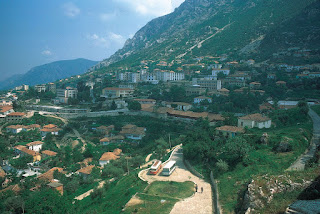
Albania
in southern Europe, located in the western part of the Balkan Peninsula on the Strait of Otranto, the southern entrance to the Adriatic Sea Albanians refer to themselves as shqiptarë—often taken to mean “sons of eagles,” though it may well refer to “those associated with the shqip (i.e., Albanian) language”—and to their country as Shqipëria.
Because of its location on the Adriatic and Ionian seas, Albania has long served as a bridgehead for various nations and empires seeking conquest abroad. In the 2nd century bce the Illyrians were conquered by the Romans, and from the end of the 4th century ce they were ruled by the Byzantine EmpireThey have lived in relative isolation and obscurity through most of their difficult history, in part because of the rugged terrain of their mountainous land but also because of a complex of historical, cultural, and social factors.
Albania was declared independent in 1912, but the following year the demarcation of its boundaries by the great powers of Europe (Austria-Hungary, Britain, France, Germany, Italy, and Russia) assigned about half its territory and people to neighbouring states. Ruled as a monarchy between the World Wars, Albania emerged from the violence of World War II as a communist state that fiercely protected its sovereignty and in which almost all aspects of life were controlled by the ruling party That shift reflected the country’s continuing orientation toward the West, and it accorded with the Albanian people’s long-standing appreciation of Western technology and cultural achievements—even while retaining their own ethnic identity, cultural heritage, and individuality.
Land of Albania
Albania’s immediate western neighbour, Italy, lies some 50 miles (80 km) across the Adriatic Sea. Albania has a length of about 210 miles (340 km) and a width of about 95 miles (150 km).
Relief
The North Albanian Alps, an extension of the Dinaric Alps, cover the northern part of the country. With elevations approaching 8,900 feet (2,700 metres), this is the most rugged part of the country. It is heavily forested and sparsely populated South of the central mountain region is a series of northwest-southeast-trending mountain ranges with elevations up to 8,200 feet (2,500 metres). Composed of limestone rock, the ranges are separated by wide valleys. Unlike the Alps and the central region, which are covered with dense forests, Stretching along the Adriatic coast over a distance of nearly 125 miles (200 km) and penetrating some 30 miles (50 km) into the interior are the low, fertile plains of western Albania.
Drainage
the Seman, Shkumbin, and Vjosë, all of which drain the central part of the western plains. Albania also has many lakes, the most important of which are Lake Scutari (known in Albania as Lake Shkodër) in the northwest and Lakes Ohrid and Prespa along the eastern border.


